Timeline: 1997 – 2007
Location: Throughout the Catlow Valley
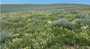
Purpose: Study various characteristics of and effects of grazing on winterfat
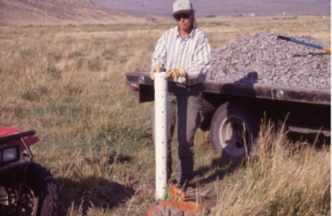
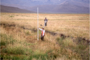
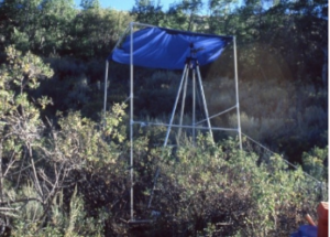
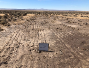
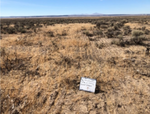
Summary: Winterfat (or white sage) is a valuable forage species with an average of 10% crude protein during winter when there are few nutritious options for livestock and wildlife. However, excessive grazing throughout the west has negatively impacted survival of winterfat stands. The Catlow Valley is near the northern extent of the range of winterfat throughout thewestern US. Three 40m x 40m plots were established at each of 15 locations across the Catlow Valley, a control plot that was not fenced, a large animal exclosure with standard five strand barbed wire fencing, and a large and small animal exclosure with five strand barbed wire fencing and chicken wire along the bottom two feet of the fence. These plots were used to study the effects of grazing/rest on seed viability. Statistical analyses found that there was no difference in mean seed viability levels between the three plots at each location or across the 15 locations after four years.
An additional area was fenced to determine if four different seedbed treatments (rip, harrow, till, control) resulted in differing emergence and survival rates of winterfat and squirreltail (grass) seedlings. Winterfat seedling emergence and survival was highest in the tilled treatments and squirreltail seedling emergence and survival did not differ between treatments. Additionally, forage quality was measured each month for four dominant species in this system: Nuttall’s saltbush, winterfat, creeping wildrye, and squirreltail – and a forage calendar was created showing nutritional value by species each month to assist with livestock management.
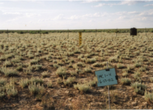
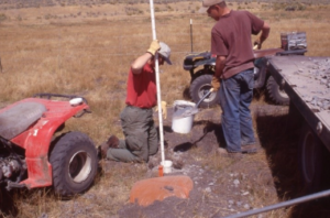
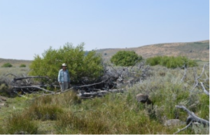
The large and small animal (L) and large animal (R) 40m x 40mexclosures at one of 15 locations in the Catlow Valley used to study winterfat.
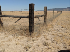
The large and small animal exclosure constructed of a 5 strand barbed wire fence and chicken wire along the bottom. The large animal exclosure without chicken wire is in the background.
Person/Organization: RSR
Timeline: 1997 – present
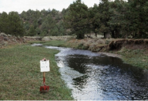
Location: Along streams on the ranch
Purpose: Document change over time in several riparian areas
Summary: Photo point monitoring is one way to document change in a landscape over time by taking photographs at the exact same location several years apart. The ranch has established several sets of photo points at different locations primarily along streams. Photo points on Lower Skull Creek and Home Creek go back as far as 1979 and have been repeated several times since then. Photo points on Upper Skull Creek go back to 1997 and have also been repeated several times since then. Positive changes in stream morphology, bankside vegetation, and surrounding vegetation have been observed in these series of photo points.
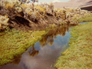
Paired photos showing riparian vegetation change along lower Skull Creek (top) and lower Home Creek
(bottom) between 1979 (left) and 2016 (right).
Person/Organization: USFWS, Gary Ivey, Caroline Herziger
Timeline: 1998 – 2011
Location: Home Creek and Skull Creek
Purpose: Quantify changes in bird use and vegetation in riparian areas
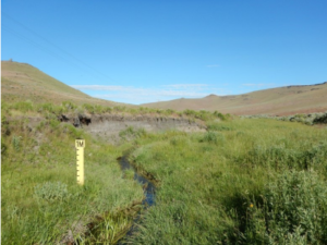
Summary: Riparian areas are important breeding and summer use areas for small neo-tropical migrant birds and bird use of these areas can be an indicator of their health. Similarly, willows, aspen, and other streamside vegetation can also be a sign of a healthy riparian area. In 1998 as part of the redband trout Candidate Conservation Agreement, point counts and vegetation surveys were initiated along Upper and Lower Skull Creek and Upper and Lower Home Creek. One route with 30 points each spaced 150 m apart was established on each of the four sections of stream. At each point the number and species of birds was recorded for each bird seen or heard. within a 50 m radius circle, beyond the 50 m radius circle, and for fly overs. Vegetation surveys quantifying several characteristics of the stream morphology and bankside vegetation were also recorded. Additionally, photos were taken in the up and down stream direction at each point. Each route was completed three times at approximately ten day intervals
beginning in mid-June in 1998 and repeated in 2011. The number of riparian bird species remained relatively stable between years. There was an average increase of 426% for willows across the four stretches of stream and an average increase of 255% for aspens on the two upper stretches of stream (aspens were absent on the lower elevation stretches on each stream) in 2011. There was also significantly increased depths along three of the four stretches of stream in 2011.
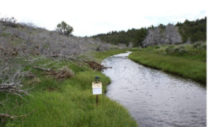
Paired photos showing riparian vegetation change at 2 locations along Home Creek
between 1998 (left) and 2011 (right).
Person/Organization: Tamzen Stringham, Gwen Taylor, W.C. Krueger, OSU
Timeline: 2001-2002
Location: Skull Creek lower meadow
Purpose: Determine how flood irrigation of a nearby meadow influences stream temperature
Summary: Maintaining cool stream water during the hot summer months is important for redband trout, the native trout species on the ranch. Lower Skull Creek flows out of Skull Creek Reservoir then through and along the edge of several irrigated meadows before continuing down a broad canyon. This project looked at the differences in stream temperature depending on if the lower meadow was irrigated or not. A series of small diameter wells were installed along transects across the meadow and were outfitted with devices to measure the water table and record how much of the meadow was irrigated. Stream temperature loggers were also placed at several locations in the creek above, through, and below the meadow. The stream temperature was cooler when the meadow was irrigated, suggesting water was traveling through the meadow underground, then entering the stream as cooler water.
**Photos showing the construction of the small diameter wells and measurement of the
water table of the irrigated meadow.

Person/Organization: Tamzen Stringham, Steven Petersen, OSU
Timeline: 2000 – 2006
Location: Upper Skull Creek Canyon
Purpose: Influence of western juniper on infiltration, runoff, and sediment yield
Summary: Western juniper is a native species, but has been expanding into sagebrush rangelands with the absence of widespread fire over the last 130 years. It can affect sagebrush communities by altering the amount of precipitation that reaches the soil and by its high use of soil moisture. Rainfall was simulated during this project and infiltration, runoff, and sediment yields were measured in three juniper canopy cover levels (high: >22%; moderate: 13% – 16%; and low: <3%) within each of the four primary aspects (north, south, east, west). Infiltration rates on control plots were 68% higher than high juniper cover sites and 34% greater than moderate juniper cover sites on south facing slopes. There was no difference between control and treatment on north facing slopes. Highest infiltration rates were positively associated with increased surface litter and shrub cover. Depth of water within the soil profile was lowest in high juniper cover plots, suggesting that less water is available to sustain understory and
intercanopy plant growth in areas with high juniper cover. Several other related projects developed GIS-based models to predict plant community structure in relation to western juniper establishment and tested a process-based application of state-and-transition models on western juniper encroachment.
** Photos showing representative landscape, data collection, and rain simulator device in
Upper Skull Creek Canyon.
Person/Organization: Tamzen Stringham, Casey Matney, Chad Boyd, OSU
Timeline: 2002 – 2003
Location: Smith Flat
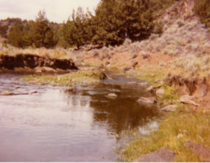
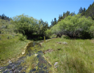
Purpose: Determine how placing felled junipers across a stream influenced willow growth,
water temperature, and redband trout use
Summary: Willow communities are important components of riparian ecosystems. However, browsing by livestock and wildlife species can negatively impact willow size and abundance, and make restoration efforts difficult. A common solution has been fencing of affected willows to
exclude ungulates, but fencing is expensive and may not complement desirable land management strategies. An alternative to fencing is the use of structures that limit access to streamside willows, without excluding ungulate access to the entire riparian zone. Junipers that were cut in Little Skull Creek Canyon were placed over Home creek in 150 m sections, separated by an equal length of uncovered stream. Willows were measured both before and one year after the junipers were placed. Stream temperature loggers were also used to measure differences in temperature. At the same time, redband trout were caught and had radio trackers attached to them to monitor use of the covered and uncovered sections of stream. Within one year of the trees being placed over the stream, the average growth of willows in covered treatments was 480% greater than in noncovered treatments and more shrubs were browsed in noncovered (84%) than covered (39%) treatments. Temperature loggers showed that covering the stream slowed the rate of water heating during the day, but did not change the overall temperature of the water. Also, redband trout used covered areas more than uncovered areas of the stream.
Photos showing Home Creek pre-treatment, aerially after junipers were placed, a fish
tracker receiver and several years post treatment.

Person/Organization: Barry Perryman and Bob Alverts, UNR
Timeline: 2011 – current
Location: South end of Catlow Valley
Purpose: Utilize grazing to reduce cheatgrass density and improve native grass production
Summary: Cheatgrass is a non-native invasive grass that has spread throughout the Great Basin, but has low value to livestock and wildlife. It has the ability to out-compete many native grasses by using the soil resources early in the spring while native species are still dormant. Cheatgrass does particularly well when previous years’ dead plants are not removed by grazing or other means. The ranch fenced a ~1400 acre pasture where cheatgrass was dominant in the understory. This pasture is grazed heavily each year late in the fall or winter with the goal of removing the previous year’s dead plants and reducing the dominance of cheatgrass. Native grasses will then have a better chance to establish and outcompete the cheatgrass for available resources.
Paired photos of two different photo points showing end of summer cheatgrass growth pre-grazing (left) and spring cheatgrass reduction post-grazing (right).
Person/Organization: RSR
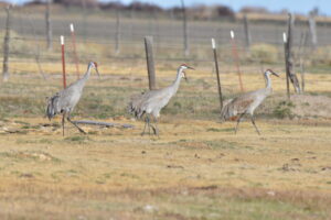
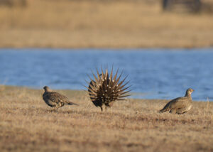
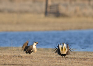
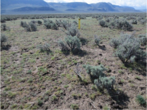
Timeline: 2013 – Present
Location: Throughout the ranch
Purpose: Determine and monitor important sage-grouse population parameters and seasonal use of the ranch
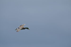
Summary: Sage-grouse are a sagebrush obligate species found in 11 western states. Their populations have declined from historical numbers and they are now considered a candidate species for listing under the Endangered Species Act. The ranch has several leks (breeding areas) and a large number of sage-grouse on the ranch during different seasons. The ranch began a large project to count males displaying at leks annually during breeding season and to radio-collar and track sage-grouse throughout the year. An average of 23 birds (primarily hens)/year have been captured and fitted with radio and/or GPS tracking devices and over 24,000 GPS locations have been acquired since 2013. Annual nest success and production has also been monitored from the marked birds on the ranch. These population parameters and the population itself fluctuate from year to year based on a number of environmental factors. These data have given the ranch a good understanding of how sage-grouse utilize the ranch
seasonally and helped the ranch design and implement annual grazing plans, and locate and prioritize habitat improvement projects and other management activities.
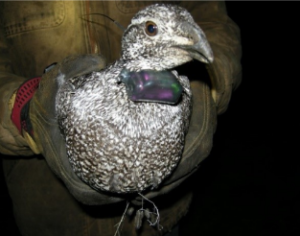
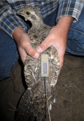
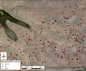
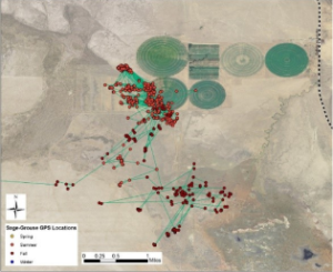
Photos showing a radio collared hen sage-grouse, a hen outfitted with a satellite GPS transmitter, and maps showing sage-grouse locations around
V Lake and the Dry Creek Pivots.
Person/Organization: RSR
Timeline: 2014 – Present
Location: Along Catlow Rim
Purpose: Monitor golden eagle nesting area occupancy, nest success and chick recruitment
Summary: Golden eagles use the rims on the east and west sides of the Catlow Valley to nest and rear their chicks. There are 13 breeding areas on the east and west Catlow Rims, and each breeding area typically has 2-3 nests. A golden eagle pair will rotate between the nests in successive years. This project monitored three aspects of golden eagle nesting biology annually: 1) whether or not each breeding area was occupied; 2) if occupied, whether or not chicks successfully hatched; and 3) if chicks hatched, whether or not they survived to 49 days old, which is the age at which they are assumed to be recruited into the population. This effort was part of a larger Oregon statewide project on golden eagle nest success from 2010 – 2020. From 2014-2021, 42 golden eagle chicks were recruited into the population at the breeding areas on the ranch.
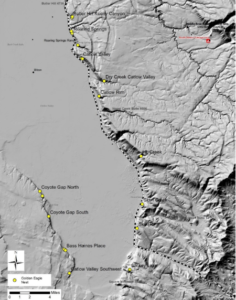
Map showing golden eagle breeding areas and nest
locations along the east and west Catlow Rims.
Person/Organization: Sergio Arispe, OSU Extension
Timeline: 2017 – 2020
Location: South end of Catlow Valley
Purpose: Test different treatments to increase perennial grass understory
Summary: In some areas sagebrush rangelands have become degraded because the understory has shifted from perennial grasses to invasive annual grasses. The ranch provided an experimental plot for this project and treatments were applied inside the plot including different combinations of herbicide application, prescribed burns, disking, and seeding with a rangeland drill. After each treatment half the area was seeded with native perennial grass seeds and half was seeded with introduced perennial grass seeds. Perennial grass density increased after treatments but total cover did not, possibly due to the plants being young and having less cover than older plants.
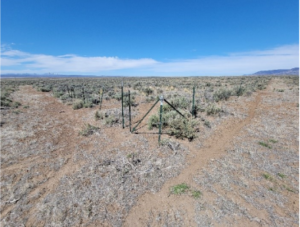
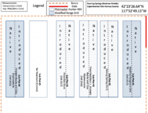
Photos showing study area, treatment diagram, and photo points after treatments.
Person/Organization: Matt Madsen and graduate students, BYU
Timeline: 2017 – current
Location: Long Hollow
Purpose: Increase the success of reseeding native species by applying different seed coatings
Summary: Many native plant species in the Great Basin, especially at lower elevations, don’t readily reestablish after a disturbance, such as a wildfire. One problem is that seeds planted in fall germinate too early and die during winter, and seeds planted in spring germinate too late when soil moisture is insufficient. Coatings made up of different substances applied to the seeds before they are planted could help with the timing of germination. The ranch provided an experimental plot where grass and shrub seeds coated with hormones were planted and are being monitored as part of a larger project.
Photos showing native grass plants successfully germinating in seed-coating trial plots.
Person/Organization: Chad Boyd, David Bohnert, Dustin Johnson, ARS/OSU
Timeline: 2018 – present
Location: Skull Creek Basin
Purpose: Determine effects of horse season-long-grazing impacts to sage-grouse habitat
Summary: Wild horse and sage-grouse habitat overlap in many areas of the western US. While the timing, duration, and amount of cattle grazing can be controlled and managed, wild horse grazing is primarily season long and unmanaged. As wild horse populations have increased there is a potential conflict between this season-long unmanaged grazing and sage-grouse habitat needs. The ranch fenced a ~1400 acre pasture in an area where sage-grouse nest and rear broods. Six paired plots (one fenced control and one treatment) were established and vegetation was measured and quantified for two years. Additional sage-grouse were also captured and radio collared at the leks nearest to the pasture to get an idea of nest success inside the pasture before, during, and after horse use. A band of ranch horses are being used as surrogates for wild horses and will graze in the pasture year round except for the winter months. Vegetation measurements at the six plots will continue each year while horses are present and after they are removed. Additionally, several utilization cages installed along a creek in the study pasture will show changes in vegetation in these areas.
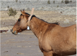

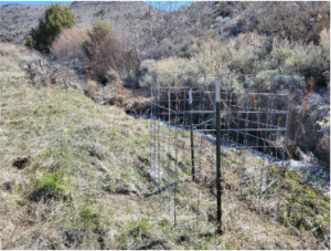
Photos showing GPS-collared horses shortly after collars were attached (top left), grazing
in the study pasture, and a utilization cage near a creek in the study pasture.
Person/Organization: ODFW and RSR
Timeline: 2018 – present
Location: Throughout the ranch
Purpose: Gather information on mule deer movements on the ranch
Summary: As part of a larger project to better understand mule deer movements in the Steens Wildlife Management Unit, ODFW captured three does on the ranch, attached GPS collars, and released them in February 2018. The ranch purchased an additional four GPS collars and had them placed on does at the same time. Each collar generally records 1-2 GPS coordinates per day and connects to a satellite to upload the data. The data from these collars have helped the ranch learn more about seasonal mule deer use of the ranch and with prioritizing and placement of habitat improvement projects.
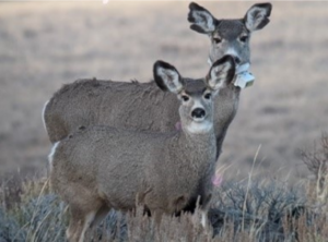
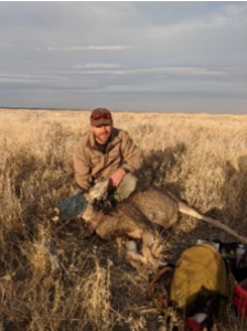
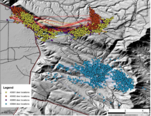
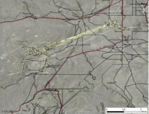
Photos showing a GPS collared doe, a doe that was tranquilized and fitted with a GPS collar and
maps showing collared deer seasonal use of the mountain and valley.
Person/Organization: RSR
Timeline: 2018 – present
Location: In Upper Skull Creek at the bottom end of Upper Skull Creek Canyon
Purpose: Monitor stream flow and determine its relationship with management projects
Summary: Juniper cutting and other landscape management projects influence nearby stream flow rates. Upper Skull Creek Canyon has had limited juniper cutting and other projects. In March 2018, a flume was installed in the creek at the bottom of the canyon. The flume includes two sensors (one under the water and one above the water) that record temperature and atmospheric pressure every 30 minutes. By using the difference in pressure readings and a formula quantifying the volume of water in the flume, the flow rate can be calculated. The goal of this project is to monitor stream flow rates through the year before, during, and after different projects are completed in the canyon, particularly juniper cutting. It is anticipated that stream flow will increase as junipers are cut and their high use of soil moisture is eliminated.
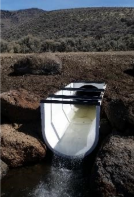
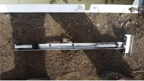
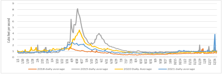
Photos showing the installed flume, the bracket holding two pressure sensors that attaches to the side of
the flume, and a chart showing stream flow recorded at the flume 2018-2021.
Person/Organization: Alan Rogers, John Barrett, Ken Wilson, MIT Haystack Observatory
Timeline: 2019
Location: Skull Creek Basin
Purpose: Confirm a previous finding from Western Australia about hydrogen in the atmosphere
Summary: The area around Skull Creek Butte and Skull Creek Reservoir has been identified as the area in the United States with the lowest amount of radio interference. Scientists from Haystack Observatory at MIT deployed a specialized antenna to monitor a specific radio signal from hydrogen in the universe. A similar antenna was deployed in Western Australia at another radio quiet zone and an important discovery was made about the presence of hydrogen in and the timing of the formation of the universe. The scientists deployed their antenna near Skull Creek Butte in the fall of 2019 in an attempt to confirm the previous finding. The absence of radio interference near the ground allowed their antenna collect data, but unanticipated atmospheric radio interference from large regional cities negatively affected their data.
Person/Organization: Tamzen Stringham, Steven Petersen, OSU
Timeline: 2000 – 2006
Location: Upper Skull Creek Canyon
Purpose: Influence of western juniper on infiltration, runoff, and sediment yield
Summary: Western juniper is a native species, but has been expanding into sagebrush rangelands with the absence of widespread fire over the last 130 years. It can affect sagebrush communities by altering the amount of precipitation that reaches the soil and by its high use of soil moisture. Rainfall was simulated during this project and infiltration, runoff, and sediment yields were measured in three juniper canopy cover levels (high: >22%; moderate: 13% – 16%; and low: <3%) within each of the four primary aspects (north, south, east, west). Infiltration rates on control plots were 68% higher than high juniper cover sites and 34% greater than moderate juniper cover sites on south facing slopes. There was no difference between control and treatment on north facing slopes. Highest infiltration rates were positively associated with increased surface litter and shrub cover. Depth of water within the soil profile was lowest in high juniper cover plots, suggesting that less water is available to sustain understory and intercanopy plant growth in areas with high juniper cover. Several other related projects developed GIS-based models to predict plant community structure in relation to western juniper establishment and tested a process-based application of state-and-transition models on western juniper encroachment.
Representative landscape pre-fire showing decadent sagebrush with few plants
growing underneath.
Aerial picture taken immediately after prescribed fire showing burned and
unburned mosaic.
Increased grass and forbs as a result of prescribed fire (foreground) compared with
sagebrush dominated landscape that didn’t burn (background).
Person/Organization: RSR employees/contractors
Timeline: 1997 – present
Location: Primarily upper areas of Skull Creek Basin and on the mountain
Purpose: Increase soil moisture available to other plants and restore ecological function
Summary: Western junipers are native to the ranch but are an invasive species. Historically, frequent wildfires limited junipers to steep, rocky areas and other areas fire didn’t readily burn. Human suppression of wildfires for the last ~130 years has allowed junipers to expand into sagebrush rangelands and into areas previously dominated by aspen and willow. Once established junipers can outcompete other native species and can use up to 40 gallons of water per day when it is available in the soil. Coupled with prescribed fire and other management tools, the ranch has been actively cutting junipers in different areas since 1997. Cutting junipers, particularly when paired with prescribed fire, has increased grass and shrub production on the ranch. The ranch has also used cut junipers in creative ways (e.g., as
exclusion fencing around riparian and spring areas, as cover over an exposed stream, etc.) to meet other management objectives.
Person/Organization: RSR
Timeline: 1997 – present
Location: Primarily on the mountain
Purpose: Increase size and abundance of aspen stands
Summary: Aspen has been declining across the western US as it is overtaken by conifer trees and is susceptible to browsing by livestock and wildlife species when young. Disturbance on the landscape such as fire or other mechanical treatments stimulates aspen to resprout. Prescribed fire and other treatments in and near aspen stands on the ranch have led to large increases in abundance of trees and size of stands. Grazing management and large treatment areas have allowed the young trees to grow tall enough to avoid being browsed by livestock and wildlife
Person/Organization: Tamzen Stringham, UNR
Timeline: 2001
Location: Lower Skull Creek at the bottom end of the lower meadow
Purpose: Permanently repair a headcut
Summary: Headcuts are formed when a stream erodes away an incision in the stream bed and can increase in size and move upstream if not repaired. Several check dams had washed out on Lower Skull Creek, possibly causing a head cut in the stream. The head cut area was excavated and fabric and rock was laid down to replace the drop off with a gradually sloped area in the stream bed. The native vegetation quickly filled back in the excavated area and the repair helped the stream return to a functioning system.
Person/Organization: Jeremy Pinto, USFS, Jeff Everett and Angela Sitz, USFWS, Gail Redberg,
Tribal Nursery
Timeline: 2017 – present
Location: Long Hollow and Skull Creek Basin
Purpose: Monitor and increase success of planting seedlings near the seed source
Summary: Natural resprouting of sagebrush and bitterbrush following disturbance has low success rates. A fairly new approach is to grow seedlings of these shrubs in a nursery and then plant the seedlings on the range. This approach has had higher success rates but still is not a proven method. This project is evaluating the success of planting seedlings in the same ecological and climatological area as the seed was collected from. The ranch is participating in this project as part of the its efforts to improve sage-grouse habitat and increase sagebrush abundance in areas that had burned in wildfires. Seeds are collected from the shrubs in the summer (bitterbrush) and fall (sagebrush) and taken to the greenhouse where they are planted and cultivated eedlings (6” – ”) are then planted at the ranch in fall or spring and monitored for success rates.
Person/Organization: RSR employees/contractors
Timeline: 2000
Location: Bunny Creek and Deep Creek
Purpose: Utilize felled juniper trees for temporary riparian fencing
Summary: Riparian areas along streams and around springs are important areas for wildlife and fish. They can also be areas of livestock concentration during hot summer months. The ranch identified several sections of stream and two springs that would benefit from temporary livestock exclusion. Typically some type of fencing would be used, and the associated costs of construction, maintenance, and removal would be incurred. The ranch was cutting junipers in these areas during the same timeframe, and realized an opportunity to use the felled junipers placed against one another in a line to construct a temporary “fence”. When the fence was no longer needed, the junipers were burned to remove it.
Person/Organization: RSR
Timeline: Summer 2014
Location: Between Lower Skull Creek and Long Hollow
Purpose: Provide additional water sources for wildlife
Summary: Guzzlers are man-made water systems that collect and store precipitation, and provide that water for wildlife in areas where natural water sources are limited. During summer 2014 two guzzlers systems were installed on the ranch with the goal of providing water
sources for bighorn sheep near their lambing areas along with other wildlife species. These systems have a 352 ft2 surface area to collect rain and snow and 1000 gallons of storage capacity. They were installed near known bighorn sheep and mule deer use areas where natural water sources are limited, and fenced to exclude livestock use. Motion activated trail cameras were used to monitor wildlife use after the guzzlers were installed and several species of mammals and birds were documented using them.